


All About Arthur
As Fourth of July weekend approaches and hundreds of people head down the shore, it pays to keep an eye on the activity of Tropical Storm Arthur, which threatens to move north and become a full-blown hurricane. Here’s the rundown on where Arthur is headed and what that means for your holiday weekend.
At Present
As of 6 PM yesterday (July 1st), Arthur was hovering off the coast of Florida and gathering strength. The approach of a trough in the jet stream means that the storm will likely accelerate over the next couple of days.
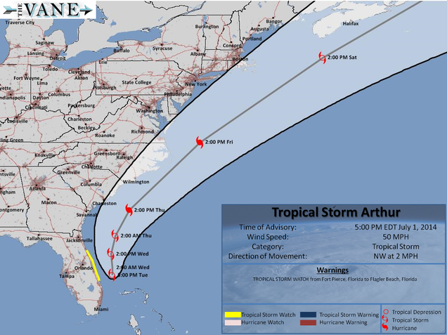
Image courtesy of the NHC
What’s Next
A NOAA forecast predicts that the storm is likely to become a Category 1 hurricane when it moves northwest and collides with the Outer Banks of North Carolina, probably on Thursday night (July 3rd) into Friday evening (July 4th). Residents and visitors to that area can expect high winds (80 to 90 mph), heavy rains that could possibly lead to flooding, and strong rip currents that pull swimmers away from shore. From North Carolina, Arthur is expected to travel roughly parallel with the northwestern Atlantic coast, eventually hitting Newfoundland as a subtropical storm.
What to Remember
The effects of tropical storms and hurricanes are not contained to one specific area. Even if forecasters are correct and the storm moves in a northeastern direction, Jersey shore beachgoers should expect higher tides and rougher waves throughout the weekend as Arthur passes by.
Forecasts are not exact, so be prepared! Even the most accurate predictions can only identify a certain (fairly wide) radius in which the storm’s center may be at a given time. If Arthur follows a path further to the west than predicted, it could create dangerous conditions in coastal areas from the south up through New England.

Image courtesy of USA Today
How to Prepare
–Be aware of your surroundings. If you’re staying at a beach house or rental property near the shore, determine the elevation level of the house and whether the land is flood-prone to determine how your property will be affected in the event of a storm surge or tidal flooding.
-Be sure trees and shrubs around your property are trimmed to be more wind resistant.
-Clear loose and clogged rain gutters and downspouts.
-As soon as winds pick up, bring in all outdoor furniture, decorations, garbage cans, and anything else that is not tied down securely.
-Keep a backup generator and battery-operated radio in case there is a power outage.
-Check weather reports and tide patterns before heading to the beach. If the surf is too rough, you and your family could be in serious danger.
– IF YOU ARE TOLD TO EVACUATE THE AREA, DO IT. Don’t hedge your bets on something so unpredictable and destructive.